
Birmingham City Council published their draft Transport Plan 1 year ago.
The Plan aims to reduce vehicle impact on the environment, eliminate road danger, create jobs and opportunities, prioritise pedestrians, and revitalise major areas.
1 year on, what has been achieved?
Pedestrians and the Emergency Plan
The pandemic meant that fewer cars were on the road in Spring and Summer 2020, and the Council seized the opportunity to publish their Emergency Birmingham Transport Plan in May 2020.
Pavement widening to allow for social distancing and increased pedestrian flow has been put in place in some areas, such as on Temple Row in the city centre, and the centres of Stirchley and Moseley.
Low traffic neighbourhoods, like those trialled in London in London, have been put in place in Kings Heath. These are designed to block or discourage traffic from residential areas to improve air quality and road safety.
Schemes to close roads near schools are being extended too, to increase the amount of people walking or cycling to school. The Modeshift STARS scheme has been encouraged, to help schools with sustainable travel plans.

Roadway changes
The draft plan wanted 20mph to be the default speed for vehicles in residential areas and local centres.
The government rejected a plan to do this in one go in May 2020, telling Cllr Waseem Zaffar that the burden on police to enforce it would be too great during the pandemic.
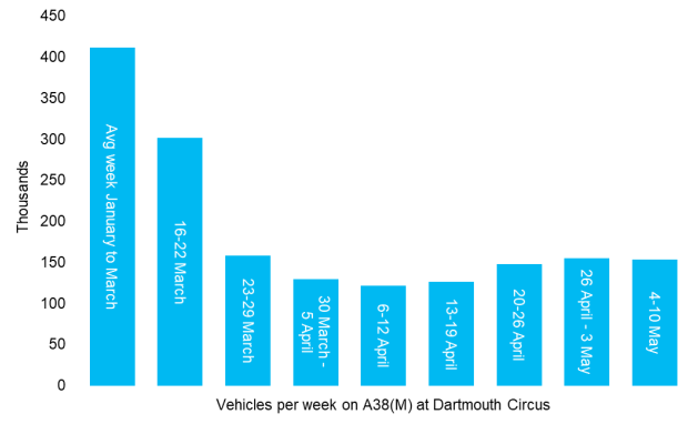
Pop-up cycle routes have been marked out on roads like the A38 through Selly Oak, and Coventry Road and the A45 leading into the city centre. Road space has been reduced for these, and plans for further pop-up routes are planned.
Temporary parking has been opened up at Selly Oak train station and St. Andrew’s stadium car park, to allow people to continue their journeys on foot or by bicycle.
Several routes in the city centre have been blocked to traffic to create “segments”, forcing traffic back out to the A4540 Middleway if they want to access another “segment”.

What remains to be done?
The Transport Plan contains proposals reaching into the 2030’s, so there is much work to be done before the Plan’s dream is realised.
The Clean Air Zone, which will charge a fee to drivers using inefficient cars, should come into effect in the Summer of 2021. This will cover all roads inside the Middleway.

The Council are still pursuing 20mph speed zones in most areas – when this will be achieved is currently unclear.
The Sprint bus network – starting with a direct route from Walsall to Solihull through the city centre – should be in place in time for the Commonwealth Games in 2022.
A “One Station” plan – finding a way to connect Moor Street, New Street, and the Curzon Street Station for HS2 – is on the cards for the middle of the decade.
The Metro lines will continue to be expanded over the next ten years too, with new lines in the city centre, and new routes to Solihull and other areas.
Are you excited about the changes coming to Birmingham over the next ten years? Or have you been affected by the current emergency plan? Let us know in the comments, or tweet us @bhameastside.